
Rotherham, South Yorkshire

Heat Loss Survey Rotherham

Room-by-room measurements, visible fabric assumptions and organised evidence for installer teams working across Rotherham's urban, suburban and rural housing.

Completed Rotherham surveys · reports from £150 · measured and desktop routes · full UK coverage.

Send the Rotherham postcode with any plans, extension details or construction records. The reply will confirm the evidence route, travel, price and expected turnaround.

Heat loss survey Rotherham: local homes and building types

Rotherham combines dense streets close to the town centre, broad suburban estates, newer developments and outlying villages. A local calculation has to follow the building in front of us rather than treat the whole borough as one housing type.

Housing mix

Almost half the homes are semi-detached

Census 2021 recorded 49.2% of Rotherham households in semi-detached homes. Detached properties accounted for 22.3%, terraces 18.2% and purpose-built flats 8.7%.

That mix changes exposed wall area, party-wall treatment, roof form and the number of elevations that need to be measured.

Borough scale

Urban, suburban and rural homes share one borough

Rotherham's ward profiles describe 25 wards covering urban, suburban and rural areas, with 70% of the borough classed as open countryside. Travel and building context can therefore change substantially between two jobs carrying a Rotherham address.

Local pattern

The housing mix changes by neighbourhood

The council's Rotherham West profile identifies substantial terraced housing in Masbrough and Ferham, with private semi-detached homes more common toward Kimberworth. Bramley and Ravenfield contain a stronger detached and semi-detached profile, while Waverley adds newer development to the south-west of the borough.

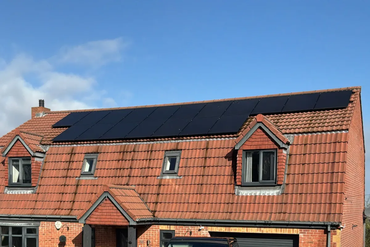
Roof and upper elevation of a three-storey detached Rotherham home surveyed by Vertex
Exterior of a three-storey detached home surveyed by Vertex in Rotherham.

A three-storey detached home with 22 surveyed rooms

This four-bedroom Rotherham property had 22 surveyed rooms, 19 windows and three floors. The main house was recorded as 2003-2006 cavity-wall construction.

Two extensions, underfloor-heating areas and six floor-plan images formed part of the survey record. Each floor and addition retained its own measured inputs and construction assumptions.

Period
2003-2006
Type
Detached
Surveyed
22 rooms
Complexity
3 floors + extensions
View the report format

Three floors, two additions and one traceable record

The featured Rotherham home needed every floor and later addition kept distinct. Its 22 room records show the designer which geometry and construction entry belongs to each part of the building.

Room data

Each floor remains identifiable

  • Twenty-two room records linked across three storeys
  • Nineteen windows assigned to the correct room and elevation
  • Underfloor-heating areas, emitters and ventilation entries recorded in context
Fabric

The additions do not inherit the main-house entry

The 2003-2006 cavity-wall entry applies to the main house. The two later additions are kept separate where their walls, floors, roofs or glazing differ.

Concealed insulation is recorded as an assumption unless site evidence or supplied documents support a firmer value.

Handover

Six floor plans anchor the handover

  • Room outputs issued with the whole-property result
  • Six floor-plan images retained with the survey measurements
  • Extension and underfloor-heating notes held in the Vertex Portal
  • Unconfirmed fabric details called out for installer review

Survey coverage and travel around Rotherham

Rotherham's road network radiates from the town centre to large settlements across the borough. Travel is planned from the actual postcode so a central appointment is not treated like a visit to Maltby, Dinnington or the Dearne Valley.

Main routes

The main roads serve different parts of the borough

The A630 links the town with Doncaster and the A1(M) to the east, and with Waverley, Sheffield and M1 Junction 33 to the south-west. The A633 serves the Dearne Valley, while the A629 connects toward M1 North.

Local access

Town streets and rural edges need different planning

Terraced streets around Masbrough and Ferham can have limited kerb space, while properties on the borough's rural edge may sit on narrower lanes or sloping plots. Access notes are checked at booking before an arrival window is agreed.

Outer areas

Maltby and Dinnington need separate diary routes

Wath and Swinton, Maltby and Bramley, Dinnington and the Wales area are planned as distinct routes rather than town-centre calls. Vertex also covers neighbouring Sheffield, Wakefield, Barnsley, Doncaster and installer projects throughout the UK.

Questions about Rotherham heat loss surveys

Included

What is included in a Rotherham heat loss survey?

A Rotherham report places the dimensions, exposed surfaces, openings, fabric, ventilation and existing emitter against the correct room. The figures are supplied with the floor plans, photographs and site notes behind them.

Desktop route

Can the calculation be completed from drawings?

Complete plans can support a desktop route when they show every heated space and distinguish later work. A visit is normally more reliable for multi-storey homes, extensions or underfloor-heating zones missing from the drawings.

Area

Which Rotherham areas does Vertex cover?

Coverage includes Rotherham town, Wath, Swinton, Maltby, Bramley, Dinnington, Wales and the borough's outlying settlements. Travel is agreed from the full postcode rather than the town name.

Pricing and booking

The Rotherham price reflects the number of heated spaces, the building's alterations and whether the available evidence supports a desktop calculation.

Heat loss only From £150

For a standalone room calculation using complete plans, existing measurements or an agreed survey record.

ASHP survey + heat loss From £350

For teams that need a new heat-pump site record and the room calculation prepared from the same evidence.